Maderas in the mud
The quick & dirty
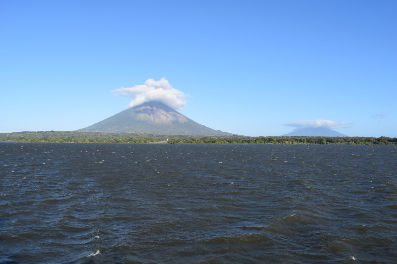
- The Maderas volcano is one of two situated on the Nicaraguan island of Ometepe in Cocibolca Lake, otherwise known as Lake Nicaragua.
- The trail from the Hotel Finca El Porvenir near the base of Maderas to the peak is a stated 8.9km (~5.53mi) one way, and can be subdivided into several sections.
- The best months to scale the volcano are from late November through the beginning of April, or outside of the rainy season.
- Allow an entire day for this activity and be prepared to get an early start.
- A guide is not obligatory, but I was glad to have one from a formal organization supplying them in those parts, Guías Unidos.
- It’s recommended that you pack snacks (if not a meal and a snack) and approximately 3 liters of water, though I consumed less.
- Wear appropriate clothing and hiking boots. See my packing list at the end of this article.
The story
One of the recent highlights of my time on Ometepe Island in Nicaragua was hiking the Maderas volcano to a spot just above the crater and lake that grace its top. It is but one of two volcanoes situated on that island alone (and one of several in the country). In fact, the Nahuatl name, Ometepe, owes itself to the presence of these two giants, as “ome” signifies “two” and “tepe” means “hill(s)”. Of the two volcanoes on Ometepe, Maderas, located in the southern part of the island, is the one that is heavily vegetated the whole way up. I would begin my day before sunrise in order to tackle it.
There are a couple of reasons to choose to hike Maderas rather than Concepción, if one must choose between the two in the first place. These include the chances of seeing wildlife and not dealing with the gases and ash released by an active volcano, since Maderas is dormant (and Concepción is not), as well as getting the chance to be in that vegetation mentioned above. The dormancy and same plant life of Maderas also give one the opportunity to see local agricultural production in certain seasons, hike under the cover of that vegetation and be in some nice shade, and get up close and personal with attractive rainforest.
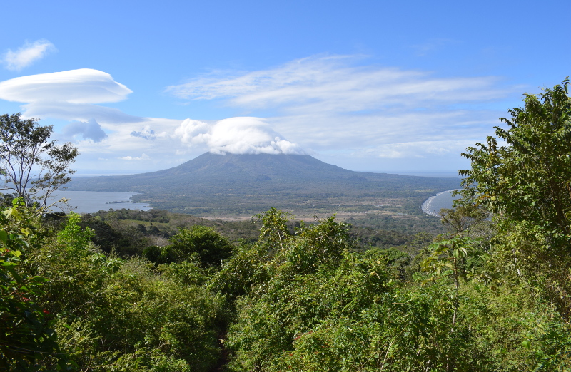
With Volcán Concepción, on the other hand, one is very much exposed while hiking most of it. Unlike with Maderas, there is also no crater lake awaiting one at the top. However, of course, with such exposure on Concepción comes the possibility to get some great views in, while your last great view on Maderas on the way up will be at the mirador (viewpoint) somewhere between 1-2 hours in. To want to continue for the rest of it, it’ll serve you well to care about hiking and being in the forest as activities, and have some hope that you get a view of that lake up top (I didn’t, though I’m still glad I got it done).
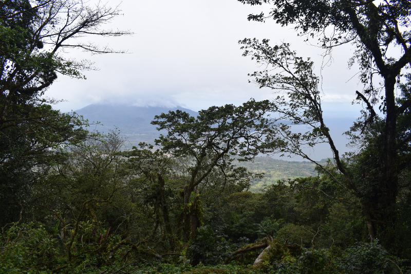
The rainforest higher up is classic and lush, and the terrain overall is challenging and varied and interesting. In some cases, one is ducking under felled trees and branches and weaving through small channels of eroded landscape and scaling over rock. A hiking stick of some kind (there are some all-natural ones kept around by the guides) comes in handy, as does a guide.
I was lucky enough to be connected with Carlos, a guide working with the Guías Unidos organization. Young, cheerful, extremely nice, and informed, Carlos filled me in on the details of the area and patiently answered questions. He also led me flawlessly all the way up in inclement weather when it really was not always clear which way one should head. Out of curiosity, I asked him how often he does the hike. Turns out that he’s out there at least four times per week, sometimes even more often, depending on the season. It’s an intense hike, so that’s a pretty intense fact.
While I went during what was supposedly the best time to hike Maderas, a period spanning the months from November through April that should be characterized by some dryness and sunshine except for the rainforest section, I personally experienced wet, and consistently muddy and slippery, conditions on the trail at the end of January of this year, most of the way. I was glad to be in adequate boots and technical clothing, with a couple of dry, warm layers in reserve along with food (a full meal) and a full water bladder in my pack (1.5L of water and I didn’t consume it all, though I tend to not need as much as the next person; 3L are recommended).
During my hike, I observed other tourists on the trail in minimal clothing and sneakers, some without any supplies of any kind, and it simply wasn’t their day (although if they could move quickly enough, they could minimize how long they exposed themselves to the elements, at least). Personally, I’d rather take my time and be comfortable, as opposed to hustling my ass around because I didn’t gear-up properly.
True, the conditions didn’t involve any torrential downpours, thankfully. However, from start to finish, Maderas was shrouded in infinite wetness; unrelenting clouds of pure mist the whole day through, making for rivulets and standing water and slick rocks and mud, lots and lots of mud, and hence, some truly slippery conditions.
Indeed, the micro climate clinging to the volcano prevented a view of any kind of the namesake lake in the crater below the top most peak of the now dormant mountain. It didn’t matter to me, though. The hike was well worth it all still, if only for the physical activity, a couple of views stolen from the cloud cover, and the opportunity to get up and close with the rainforest and hillside.
As for wildlife, I was lucky enough to be treated to sightings of various birds throughout the hike and a Capuchin monkey while descending in the late afternoon toward the lower stages of Maderas. Many comment on the birding they’ve done there, especially.
For reference’s sake, the trail can be broken up into several subsections, laid out by Carlos as follows:
- The lower “dry forest” section, which features a banana plantation and crop fields where members of the local communities grow rice, wheat, beans, and other agricultural products in rotation;
- The mirador, or viewpoint, from which one can see part of the island, the lake on both sides, and Concepción, among other things. Some visitors hike to the mirador only for the view alone, then return;
- The middle “humid/tropical forest” section, which features a coffee plantation (one can opt to hike through the plantation via an even steeper trail or bypass it);
- The rainforest section, which features repeated descents and ascents (five or so) in the upper portion;
- The crater with attendant lake down to which one can hike for a closer look or a dip in the water, then descend from there by a different route if desired.
The above being said, unless you’re staying at the Hotel Finca El Porvenir near the base of Maderas or have been given a ride there, your journey will likely start at the road below, an additional 1km or slightly less on some concrete car tracks above and beyond the stated 8.9km of the actual trail, one-way.
I myself came by bus with Carlos, who met me at my Airbnb right outside of Santo Domingo between 4-5am, because he’s awesome. The cabaña location was conveniently close to the entry point for the hike at only 4km away.
Moreover, not only was the place I rented a relatively new, well-appointed stand alone structure, but it was through the co-host there that I was connected with Carlos in the first place. I would gladly recommend the rental, co-host, and Carlos, and I would definitely stay there again on a future visit to the island (the related contact info can be found below at the very end).
Yeah, having to meet Carlos that early meant I was up before 4am after not sleeping much, to be honest. FML. Yet by the time all was said and done, I was grateful for the early start and the estimation of eight hours for the hike to be completed. While it certainly can be done more quickly (I witnessed it performed by others on the trail who began after me and finished before me), it can also be accomplished more slowly. Either way, eight hours is a good number to have in mind and begin psychologically adjusting to right off the bat.
Because of the early start I had and the weather that morning, there was no concern over getting too much sun on the lower portions that are a bit more exposed given the use of the land for farming. Once into the upper reaches of the dry or tropical forests, you can count on cover, and can especially bank on protection inside the rainforest section. You may wish to carry sunscreen just in case, but may not end up needing it. You can always just cover up instead.
Again, don’t forget to wear or load the following into a comfortable day pack. Additionally, I’ve created an associated Amazon.com Idea List with a few possible options to get you going:
- A day pack;
- A rain fly for your pack;
- Technical, quick-dry clothing, the kind you might wear for sports or cycling in harsher climates;
- A swamp brim hat or boonie;
- SmartWool socks or similar;
- Comfortable hiking boots, in good shape and with traction;
- An extra top layer or two with sleeves against the wetness, including a waterproof or water-resistant shell;
- A fair amount of water (3 liters per person recommended, though I got by on 1.5 liters) in a bladder;
- Some food, such as energy or chocolate bars, nuts or trail mix, protein, and starch – given some dietary restrictions, I had cooked myself chicken and rice the night before, packed it in a ziplock, and feasted at the top;
- Protection against wetness for your camera and phone, such as a quality camera bag or large Ziploc bags.
- Sunscreen and sunglasses, or again, just cover up.
I’m pretty sure Maderas won’t be the last Nicaraguan volcano I ever climb, but it will forever be the first…
Guide services: Carlos from Guías Unidos, +505 8822 7699. I recommend you brush up on your Spanish and contact him via WhatsApp.
Airbnb: Cabana La Ensenada
